Technology trends driving changes in geospatial applications for infrastructure operators in 2019
There are several key technology trends that will drive dramatic changes in geospatial applications for utility and communications companies in 2019 and beyond. In this blog, I take a closer look at these important areas.
- Mobility
- Open source
- Reality capture
- Machine learning
- Augmented reality
Mobility
Many business critical processes in network infrastructure companies demand accurate geospatial data for workers in the field, whether they have a network connection or not. Modern tablets and phones are great devices for mobile applications but aren’t well supported by the traditional GIS vendors and remain an afterthought for many traditional desktop applications. As a result, a surprising number of companies still use paper maps in the field!
Increasingly, companies are recognizing that they need effective mobile geospatial applications to achieve the productivity levels required to be competitive. The demand for mobile applications is increasingly driven by the ability to perform data updates in the field, which improves data accuracy and reduces the cost of maintenance. Improving data quality is key to optimizing many business processes in any infrastructure company.
Open source
For some years, the open source geospatial ecosystem has offered a wide range of mature and capable geospatial solutions. An analysis of the 23 software projects that are associated with the Open Source Geospatial Foundation (OSGeo), which represent just a portion of the overall open source geospatial ecosystem, shows that they have taken an estimated 4,560 person-years from 2,541 contributors. This is 35% more time than it took to build the Empire State Building! I believe that the use of open source components in enterprise applications will continue to grow because of their range of capabilities, speed of development, robustness and ability to reduce software licensing costs.
Reality Capture
There are a growing number of ways to build and display highly realistic and immersive models from real world images. Google Street View is one of the best known, but there are many companies providing tools to make it easy for users to capture and display their own data, both outdoors and indoors. Some of the players include Mapillary, Cupix, and HoloBuilder. Technologies are already available, and are developing rapidly, that enable field workers to be able to easily capture these models with their smart phones, consumer 360-degree cameras, drones, or vehicle mounted cameras.
This type of data is useful in many situations and has the potential to significantly reduce the number of truck rolls for network infrastructure planning, maintenance or repair. For example, if you can check ground surface information and see details of how you could run a service into a building, you can do an initial design and estimate without having to go on site.
Increasingly, there are also tools available that can automatically recognize features from rich data sets. A good example is automatically identifying and locating a power pole and determining its height. We are rapidly moving towards the point where manual updates of geospatial data in a GIS can be eliminated in many situations, dramatically driving down the cost of maintaining field data.
Machine Learning
Machine Learning is a technology that is broadly applicable to many problems and is already being widely used together with Reality Capture applications by a range of companies including Google, Mapillary and CrowdAI.
Machine learning also has significant potential in other application areas like automated design, and network problem diagnosis and resolution. For many complex problem areas, machine learning is becoming a much better solution than traditional programming.
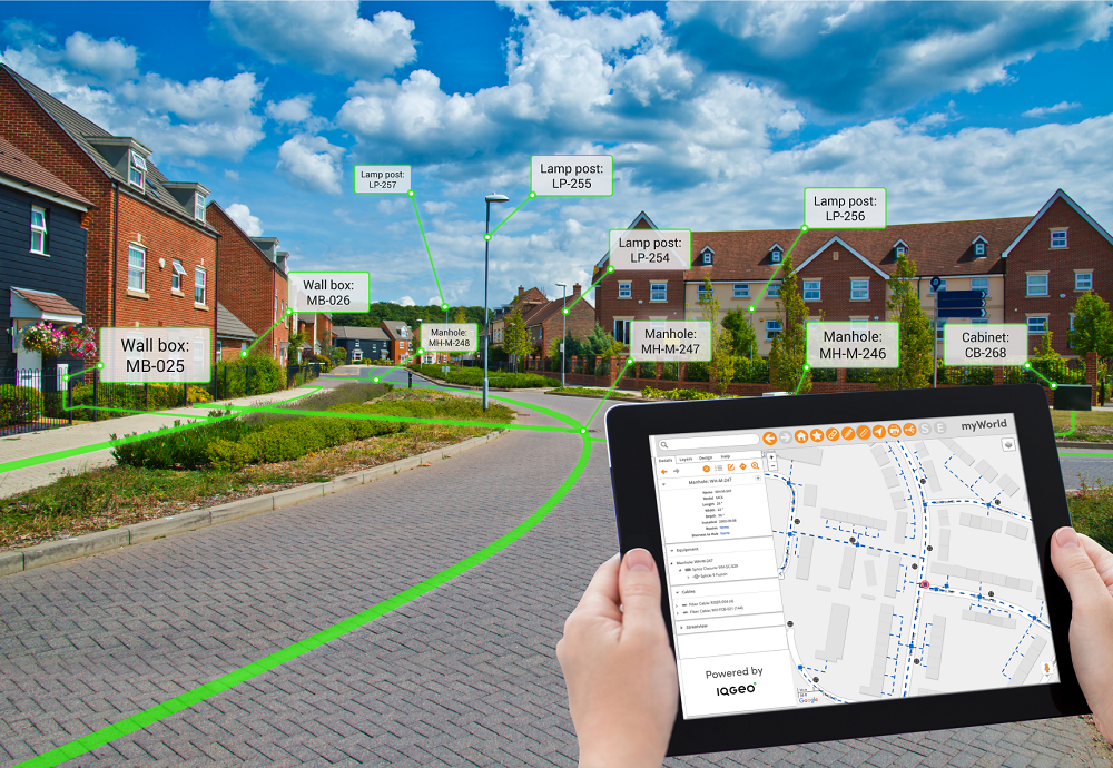
Augmented Reality
Augmented Reality is the ability to overlay relevant digital information on top of a person’s view of the world. This is done in real time on a smart phone or tablet or using smart glasses. This has great potential for use in field applications and while it is not quite there in terms of the technology for large-scale, high-accuracy applications, it is advancing rapidly.
Niantic, the developer of Pokemon Go, is planning to release the “Real World Platform” that underlies its Augmented Reality games. This will combine computer vision with machine learning to build models of the real world that can be easily used by developers. While their focus is on games, this could have a major impact on enterprise geospatial applications too.
Summary
The way that geospatial data is captured in the field is beginning to go through a dramatic change. It is moving from a intensive manual process using traditional GIS in the back office to a highly automated process in which changes are dynamically captured in the field. This will dramatically improve the accuracy and currency of geospatial data, and significantly reduce the cost of data maintenance. This will be a key enabler for the digital transformation initiatives that are so critical to the long-term success of network infrastructure companies.
Transformative next generation geospatial technology
To learn more about IQGeo's transformative next generation geospatial technology that challenges the conventional role and capabilities of legacy GIS environments, please visit: Next generation geospatial platform.

 Previous