In recent months I have had the pleasure of working with several of our utility industry customers to integrate IQGeo’s software with the Maximo workforce management solution from IBM. I have really enjoyed these projects since they have given me the chance to learn more about the challenges and priorities of these utilities, and it has also given me a perfect opportunity to see first-hand how the combination of the IQGeo and IBM software solutions are delivering benefits for field crews, management, and utility customers.
When I first speak with people about the integration of Maximo and our software, I often get questions about how these products complement or potentially overlap in functionality. While both provide quite comprehensive solutions on their own, the workforce management capabilities of Maximo dovetails nicely with the IQGeo software. To use a sports analogy, you can think of Maximo as the quarterback of a football team controlling the position of the players on the field and their responsibilities in each play that is run. In this analogy IQGeo is the rest of the team that does the blocking and running the ball down the field while feeding back valuable information about the opposition to ensure the team’s ultimate victory.
IBM Maximo and IQGeo Platform integration
With our utility customers Maximo manages the availability and assignment of field engineers and the creation and management of work orders. Field crew assignments and their associated work orders are passed directly to IQGeo and given geospatial context with IQGeo’s mobile-first Platform. IQGeo uses a combination of Maximo API’s (to extract and receive data) and IQGeo JavaScript API’s to receive orders from, and return updates back to Maximo. The updates can consist of order status changes, facility attribute edits, and new work order requests. The combined solution acts to create a single unified process to create inspection and survey job tickets, allocate staff, track ticket progress, close out jobs, and capture the field information needed to update network information and meet the needs of compliance reporting. With clear direction from the Maximo quarterback and a successful handoff to I&S, every play (i.e. work order) can score a touchdown.
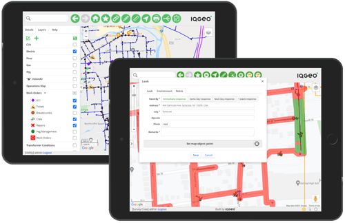
In the example tablet user interface below you see two survey inspection orders from Maximo displayed in the left panel. This provides a list of the open inspections along with crew assignments, the work that needs to be carried out, and the status of each inspection order. The panel on the right displays an IQGeo real-time geospatial view of the open inspections with visual context on the status of each job.
While winning football teams may have star players, those with exceptional teamwork deliver more consistent and predictable success. The same is true with any software integration. Each integrated component needs a clearly defined role and the workflows that draw on the resources of individuals across an enterprise must also be clear, easy-to-use and have benefits for everyone. In the case of the IQGeo and IBM integration it is the field crews, management and customers that enjoy some of the most compelling business and operational benefit.
Field crew benefits
When we first begin working with a new customer, I am often surprised just how manual many of their existing field processes still are today. Field crews are often issued paper maps and forms and may be using Excel spreadsheets on a laptop. These disconnected bits of paper and applications are very inefficient for field crews and lead to incomplete and inaccurate data collection, increased operational risk and time-consuming data entry.
By contrast the IQGeo mobile solution integrated with Maximo is delivering simple to use digital workflows that can be quickly configured for the requirements of specific inspection and maintenance processes.
Driven by pre-scheduled and reactive work orders out of Maximo, we are providing a full data roundtrip on mobile devices that automates inspection jobs and data collection. And one critical feature for field crews is the ability to work both online and offline when network connections are unavailable or down. Acceptance levels for the new mobile tools among field teams has been extremely high because it eliminates the frustration of dealing with multiple paper-based and disconnected applications. They are now able to complete jobs quickly with the inspection and survey data accurately collected and fed back in real-time to the office, saving them hours every day that can be allocated to new jobs.
Management benefits
Operational inefficiencies in the field are magnified at a management and operational control level. Inaccurate network information and not knowing where inspection teams are and the equipment they have available for specific jobs makes optimizing job and crew allocation almost impossible. The result can be assigning the wrong crew for a job or being forced to send crews to the same job multiple times which is costly, time consuming and frustrating.
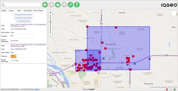
In Maximo our customers are scheduling inspections and maintenance activities and matching crews with the right experience and equipment for the job. They are also using Maximo to respond to critical situations on the ground such as gas leak detection, electrical wires down or water line breaks. The jobs are passed to the IQGeo software and management teams use the geospatial situational awareness to optimize crew assignment and incidence response. Operations centers now have a real-time view back from the field crews’ mobile devices to monitor job progress and make informed decisions quickly when emergency situations are in play. The combined solution is improving overall visibility and accountability, enhancing productivity, and reducing operational risk.
Customers benefits
Sometimes technology can distract us from the fundamental mission of servicing the customer and those organizations that I’ve been most impressed with stay 100% customer focused on everything they do. All processes and activities exist to provide a higher quality, safer service.
This customer-focused ethos is also at the heart of the recent deployments I have supported. The combination of Maximo and IQGeo is delivering faster response times with shorter Mean Time To Repair (MTTR). Geospatial situation awareness, quality network data and a holistic view of real-time job status is key to creating safer and happier customers.
Winning the game with teamwork
Returning to my football analogy, creating a team that works together is essential to the success of individual plays and to winning the game. I have seen firsthand how the integration of people, processes and technology have delivered amazing results for our customers and the IBM Maximo and IQGeo software working together is a great example of outstanding teamwork. Each application plays a clear role with Maximo directing and controlling resources while I&S manages the workflows and data collection on the ground in the field. The combination of these two best-in-class solutions is delivering a winning season for field crews, management, and customers.
 Previous