“It’s time for a change.” This was one of the key conclusions from our panel of industry experts during the most popular webinar that IQGeo has ever hosted: “Is legacy GIS failing network infrastructure companies?”.
The experts on the webinar, Linda Stevens from 51by1, Geoff Zeiss from Between the Poles and IQGeo’s CTO Peter Batty, moderated by IQGeo’s CMO Steve Tongish, discussed this leading question in depth. The three key themes that emerged from the webinar were:
- Network infrastructure providers are at crisis point
- The strategic role of data capture and collaboration
- Siloed network models that aren’t connected to the real world

Network infrastructure providers are at crisis point
As Linda Stevens pointed out, utilities and telco operators are at crisis point when it comes to data models. Having traditionally led the way in embracing emerging technologies and applying them to infrastructure in the geospatial world, they are now falling way behind.
The panel agreed that this is important because, in order to respond to customer demands and incidents, network infrastructure operators must have an accurate view of their field assets. Poor data quality has a huge impact on restoration times after outages and incidents, not to mention the impact on network maintenance and expansion. The need for near real time data is critical to understanding where the infrastructure is at risk and how to manage it effectively.
The lack of data also causes big problems when it comes to as-built backlogs. The webinar audience was asked what their average as-built update time was, the results supported the panel’s views:
- 25% said more than three months
- 28% didn’t know
- 21% said less than three months
- 8% less than one month
- 8% less than one week.
The panel also cited increasing regulatory and environmental pressures and customer demand for better, higher value services with access to immediate information, as contributing to the crisis situation. The evolution of technology and the business environment creates greater demand for up-to-date and accurate network information, which is simply not being delivered today.
Issues with data capture and sharing
Geoff Zeiss cited research estimating that the accuracy of GIS data can as low as 50%. With this stark reality, telco and utility operators are left asking, ‘should I try to fix existing GIS data, or should I start again with a different approach to data quality?’ Modern reality capture makes the latter much more practical for above and below ground data collection.
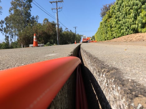
The panel discussed some of the interesting technology breakthroughs, such as ground penetrating radar that can scan networks at 135km per hour, enabling network operators to quickly and safely capture and regularly refresh key assets. Mobile phones are increasingly being used to take pictures of and locate assets, over and underground. Peter Batty referred to the sophisticated mobile apps that enable the use of sensing technologies, such as barcode, QRC, voice interaction, GPS, video and imagery, and can help with data capture in the field.

However, while the technology for new and innovative means of data capture is available, the inability to integrate this into legacy GIS is a massive barrier to utilities and telcos. The opportunity to capture large, accurate data sets in the field makes a compelling case to move to a mobile first architecture, that can maintain a near real-time view of the network. This new strategy offers significant improvements in data quality and reduces specialized, back office staff trying to cope with as-built backlogs.
The issues are not just with gathering data in the field. The panel also discussed the importance of sharing information. Billions of dollars are spent by different operators on similar investigations, so huge amounts of time and money could be saved by sharing certain data sets across organizations and sectors. For example, Geoff Zeiss highlighted some countries that are now developing underground registries that can be accessed by anyone needing to find out what’s underground in a specific location, saving time, money and lives.
Siloed network models that aren’t connected to the real world
Most of the GIS software used by network infrastructure operators was designed 20 – 30 years ago and despite the launch of new products and versions, not a lot has changed. Specifically designed for the creation of paper maps, this cartography-centric approach uses static models and is just not connected to the real world. These databases are designed for mapping, not holding and accessing massive amounts of changing data, making queries or analyzing information a very slow and laborious process.
So why aren’t network operators moving away from legacy GIS?
The consensus across the panel of experts was much the same. Network infrastructure operators are locked into their existing systems, many having been in place for decades, often with lots of customization and integration with many other business systems. Legacy GIS are complex and expensive to replace, so it remains in place through inertia.
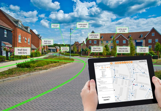
The panel believes that it’s time to move away from the old cartography-centric approach to a reality-centric strategy, which enables a business to understand where assets are and how they connect using a much simpler, more responsive data model. This approach is fundamentally tied to the mobile first approach, enabling big data to be collected in the field, where the work happens. Moving from siloed databases to a collaborative platform that is designed for managing dynamic data sets enables field and office staff to view and manage their network assets.
Steps to digital transformation
According to our panel of experts, it’s time to stop talking about digital transformation and start making it happen. This does not require major changes that are disruptive and high risk. Instead, it can start by rolling out reality-centric mobile applications running alongside existing systems in order to improve data quality and streamline operational processes. Over time the entire GIS strategy can be reimaged using the latest technology to deliver a near real-time view of the entire network, saving time, money and reducing operational risk. Network operators are at a major technology and operational crossroads and those that embrace a reality-centric geospatial approach will create a more efficient, safer and successful business.
The webinar is now available for you to view on demand.

To find out about IQGeo’s mobile-first solutions, please visit the website.
 Previous