As CTO at IQGeo, I have seen GIS implementations from all the main vendors at hundreds of infrastructure companies around the world. Based on my experience I have come to an inescapable conclusion; legacy GIS has failed network infrastructure operators.
Telecommunications and utility companies are managing extremely complex network environments. They have millions of assets across miles of networks with hundreds of field service professionals constantly maintaining equipment and expanding infrastructure.
While there are significant variations between companies, the overall quality of data that these organizations have for their critical network assets is shockingly bad. It is typical for it to take weeks, if not months, for field changes to a company’s network to be reflected in their GIS database.
We know of many companies with backlogs of tens of thousands of field updates waiting to be processed. The data gap between the office and the field shows no sign of improving.
The consequences are clear for all to see. No individual or department has an accurate view of their network assets, creating massive business inefficiencies and huge operational risks. This has a very direct and negative impact on time-to-market, maintenance and construction performance, safety, network service quality and customer satisfaction. The legacy GIS update process is simply broken and is not sustainable as network complexity increases and the expectation for safer, more responsive and real time customer service intensifies.
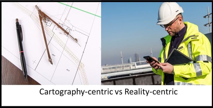
The cartography-centric past
The cartography-centric approach employed by legacy GIS providers is the fundamental reason for these failed processes. Most of these systems were originally designed 20-30 years ago and have a focus on creating and maintaining paper maps of network assets. Even more recently designed systems from legacy GIS vendors perpetuate this cartography-centric approach through their design and processes.
Representing a complex infrastructure network on paper in a 2D, non-interactive way, will never create a timely and accurate network asset view so staff cannot make rapid and informed operational decisions.
Creating and maintaining these complex maps also demands specialist skills that requires organizations to employ a team of GIS cartographers to maintain their maps. All updates must go through this back-office team, creating a critical process bottleneck.
This is further complicated by the existence of siloed applications that are often deployed around legacy GIS in an attempt to compensate for the lack of an efficient end-to-end architecture. These applications create major operational and cost overheads for the CTO and act to hinder cross-departmental collaboration across the asset lifecycle.
One large utility we talked to recently, who is regarded as having a sophisticated GIS implementation, explained that they have around 50,000 jobs in their GIS “as built update” queue. This disconnected bottleneck combined with inaccurate or incomplete information is the fundamental reason for huge update backlogs that will never deliver an accurate network view.
The result is an insurmountable data gap between field and office processes. A cartography-centric approach has a process model based around the creation of physical maps which doesn’t meet the operational needs of an increasingly sophisticated infrastructure company.
A surprising number of companies continue to rely on paper maps and excel files for field operations today. Even when they use mobile applications in the field, the functionality is often very limited, and interfaces are frequently unsuitable by field engineers. Adoption stalls and the flow of data throughout the company is further frustrated.
Still focused on proprietary solutions
To make matters worse, legacy GIS providers have failed to provide an open platform for operational applications across the enterprise and vendors perpetuate a proprietary development through their business models. Customers must use specific partners, align to proprietary file formats and system structures and key functionality is controlled and monetized.
This lack of openness creates an entire ecosystem of expensive, inefficient siloed applications and processes that further impede collaboration and productivity and perpetuate an ever-greater need for specialized technical users.
To control and evolve their network assets, operators must have functionally rich, easy-to-use field applications that break down information silos and are eagerly adopted by staff and contractors.
A reality-centric future
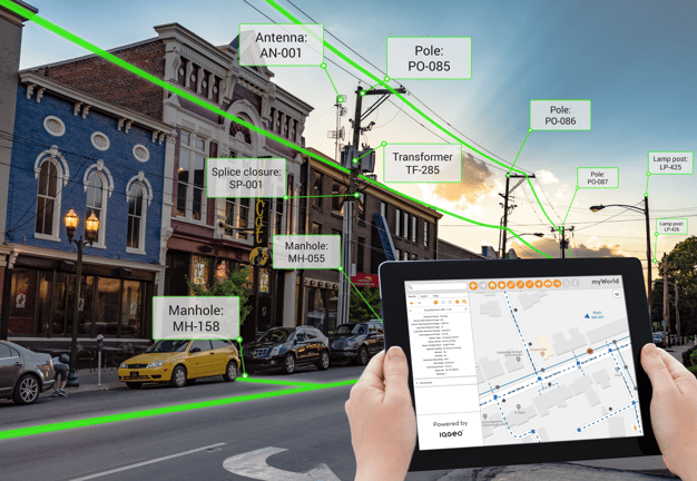
IQGeo offers a different, industry-changing approach that enables infrastructure companies to dramatically increase the quality and currency of their data, while reducing costs and streamlining processes. The IQGeo solution takes a reality-centric approach using an integrated mobile first architecture, with open applications that model the reality of a distributed, smart network using much simpler graphical representations.
This approach streamlines the maintenance process and removes inherent legacy GIS update bottlenecks. Authorized staff can now update network assets on any device, from anywhere. The result is a near real time, end-to-end view of operational realities across the enterprise. A reality-centric approach is fundamental to achieving true digital transformation strategy, putting staff in direct control of the network assets.
What makes IQGeo different can be summarized in three compelling principles:
- Reality-centric approach designed for infrastructure companies
- Integrated mobile first architecture supporting any device
- Open productivity and collaboration platform
--------------------------
1. Reality-centric approach designed for infrastructure companies
With smart, network aware applications running on field devices, it is possible to use a much simpler graphical representation of network assets. You don’t need complex mapping annotation when you can just click on the screen to see relevant information or turn on specific dynamic labels that are designed for the task at hand. You don’t need complex offset cable diagrams if you can simply ask the system to show you the upstream or downstream devices together with related network information.
The reality-centric approach provides a near real time network view that is optimized for infrastructure companies, closing the data gap between the field and the office.
The IQGeo reality-centric approach includes highly scalable network models that are specifically designed for the telecommunications and utility industries we serve. For more complex networks we use a “containment model”, in which cables and equipment are contained in hierarchical structures beneath top level equipment and structures. This is much easier and more efficient to maintain than cartographic representations where cables and equipment must be drawn and managed individually.
Reality-centric approach designed for network infrastructure companies
- Streamlines the as built update process for field and office staff
- Delivers a near real time network view that closes the field to office data gap
- Optimizes process efficiency with scalable industry specific data models
--------------------------
2. Integrated mobile first architecture supporting any device
To deliver the benefits of a reality-centric approach, it is critical to have a mobile first architecture that enables users to access and update data in the field, where and when work is done.
IQGeo’s reality-centric smart applications run exactly the same on any mobile device, as well as in any web browser. With all of the legacy GIS platforms, mobile is a second-class citizen. Mobile applications have much more limited functionality than their desktop counter parts and are based on different architectures, so functionality must be developed again for mobile use.
Designed from the ground up for mobile, the IQGeo unified architecture greatly enhances collaboration and increases productivity between field and office operations.
It enables a unique “fieldsourcing” capability for updates, similar to crowdsourcing, but instead records updates from staff and contractors in the field, when and where work happens. Over time, fieldsourcing enables companies to significantly reduce the number of data updates that require the involvement of a GIS specialist.
For companies to eliminate their reliance on paper maps, they must be confident that applications will always be available, even when there is no network connection. IQGeo mobile first applications can run online or offline on any device, using out of the box enterprise sync capabilities that are resilient, scalable and flexible.
IQGeo has a common development platform that works across all mobile devices and in any web browser. All functionality from IQGeo, as well as any custom enhancements developed by partners or customers, is independent of the operating system. This cross-platform approach is critical for a flexible mobile strategy, including support for BYOD (Bring Your Own Device) and external contractors.
Integrated mobile first architecture supporting any device
- Ensures data currency by capturing changes when and where work happens
- Supports all mobile and workstation devices with the same capabilities
- Protects operational resilience with online and offline operations
--------------------------
3. Open productivity and collaboration platform
In contrast to legacy GIS vendors with proprietary siloed applications, the IQGeo platform actually unlocks data that is hidden away in vertical applications by delivering an open application platform that operates across the entire enterprise.
Our Google Maps interface style is extremely easy to use, encouraging widespread adoption by non-technical users with minimal or no training. The platform integrates with any GIS product, or the network asset database can be maintained using IQGeo’s own end-to-end, next generation geospatial solution.
IQGeo’s open platform also integrates with other enterprise systems and applications, and can incorporate data such as jobs, outages, customer status, crew locations, device status and more. It works across the asset lifecycle, unlocking data in siloed applications that was previously inaccessible.
Operating bidirectionally, data and functionality from the IQGeo platform can be easily embedded into critical operational applications, as well as important business systems like Salesforce.
An open platform provides significant IT efficiency savings, but equally important, it breaks down application silos and creates a highly collaborative environment that improves productivity between departments and across the entire asset lifecycle.
Open productivity and collaboration platform
- Integrates with any data source, unlocking information silos
- Improves collaboration across the entire application and asset lifecycle
- Enhances productivity and user adoption with an easy to use interface
Summary
With some of the largest legacy GIS vendors now requiring major migrations projects that deliver few business benefits, their customers are at a strategic crossroads. Do telecommunication and utility operators continue to use cartography-centric systems that are not delivering the insights and performance needed to control and evolve their network assets, or is this an opportunity to make the move to a reality-centric approach?
The shockingly poor data quality and process complexity of network management strategies based on legacy GIS solutions is an increasingly high-risk choice.
Despite the heroic efforts of individuals that work for infrastructure companies, the cartography-centric approach is broken. The legacy GIS vendors have failed them, and an innovative alternative is required to meet the challenges of rolling out and managing new networks and improved customer services.
The IQGeo reality-centric approach provides an end-to-end enterprise strategy that changes the way data and assets are managed. It allows IT, operations and construction managers the opportunity to rethink the legacy approach, choosing a lower risk reality-centric strategy that puts them back in control of their network.
IQGeo is enabling businesses to deliver high value services, increase customer satisfaction and reduce the cost of field planning, design, construction and maintenance activities. A reality-centric approach is fundamental to realizing the business and technology benefits of a truly digital enterprise.
To learn more about IQGeo's transformative next generation geospatial technology that challenges the conventional role and capabilities of legacy GIS environments, please visit: Next generation geospatial platform

 Previous