
One of the challenges faced by large utilities with multiple GIS, outage management, customer information and other systems, which are often the result of mergers, is how to make spatial and associated data, in different, often incompatible systems, accessible to all users not just GIS professionals.
At Distributech 2018 Duke Energy described an off-the-shelf web-based product based on open source components that is being used by 8000 users, 2000 of them using it 24/7 every day, to access GIS and associated data in several GIS systems, both online and offline, using laptops, tablets and phones. An important advantage of the the selection process Duke used in selecting the product was that it made it possible for a relative newcomer to compete successfully with the traditional GIS incumbents.
Background
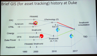
Large investor-owned utilities are often the result of mergers. For example, in 2012 Duke Energy and Progress Energy merged to create the largest U.S. utility with 7.4 million U.S. customers and approximately 52,700 megawatts of electric generating capacity. The challenge for the IT folks is how to manage the many disparate IT systems that such mergers bring together. Historically Duke Energy and Progress Energy have employed all the major GIS systems including Synercom, Intergraph FRAMME, GE Smallworld, ESRI, Intergraph GTechnology, and IBM GFIS. Accessing the valuable operational data in multiple systems is a challenge because each system has its own user interface and command structure. Over the years I have seen a number of solutions that have attempted to address the challenge of providing a common viewer for visualizing data from multiple data sources. But each has had limitations, for example, all data had to be synced to a central Oracle database, or it could only run online making it difficult to deploy to the field, or it had limited support for the many GISs and user files used by utilities, or it supported iOS on handheld devices but not Android, or did not support open standards such as OGC WMS and WFS, or did not support Google Maps, or was so complex users required extensive training and it was like pulling teeth to geth them to use iit.
At Distributech 2018 Ron York, Lead Consultant/ GIS, and Francisco Sarmento, Lead Consultant, both at Duke Energy described how Duke has resolved the problem of a common viewer for several different GIS systems which was brought to a head by the merger of Duke and Progress. They also described the somewhat unusual process by which Duke selected the vendor whose product provided the successful solution.
Open source geospatial components
A key differentiator of the product Duke chose is that it is leverages open source components; PostGIS, GeoServer and Leaflet being the main ones. The product builds on the collective wisdom, code and support provided by the worldwide open source geospatial community. Leaflet is the leading open-source JavaScript library for mobile-friendly interactive maps. PostGIS adds spatial capabilities to the PostgreSQL relational database. It extends PostgreSQL so it can store, query, and manipulate spatial data. GeoServer is a web server that allows maps and data in a variety of formats to be served to standard clients such as web browsers and desktop GIS programs. Data is published via Open Geospatial Consortium (OGC) standard interfaces, such as WMS and WFS. These are all Open Source Geospatial Foundation (OSGEO) projects.
Multiple GIS support
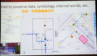
The product Duke selected supports ESRI ArcGIS, GE Smallworld, Intergraph GTechnology, spatialNET and Google Maps. At Duke it is used to access data in a couple of GISs as well as non-GIS data in Maximo, SAP, three different outage management systems, four or five customer information systems, and can link to CAD drawings and photos and images. Importantly for engineering users it preserves the original symbology and background maps of the different GIS systems.
Online and offline
Another key advantage of Duke's solution is that it can run equally well offline and online and is able to seamlessly combine and switch between online and offline data.
Mobile and office devices
It supports mobile as well as office devices, running on laptops, tablets and phones running iOS, Android, and Windows. The user interface adapts automatically for each device, displaying map layers, forms and other data in a way that is appropriate for each device.
Synced or direct access to databases
It provides two ways of accessing data; one is to periodically import or sync data into the system's spatial database, which uses PostGIS, and the other is to directly access the data via a web service. It supports ESRI REST Services, which are used by ArcGIS Online and ArcGIS Enterprise, and the industry standard OGC WMS and WFS web services, which are supported by all major geospatial vendors.
It does not support direct edit of spatial data, but does allow a GIS data correction requests to be routed through Maximo following Duke standard business procedure for making corrections.
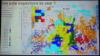
It is flexible enough to support different business processes for collecting and organizing data. For example, pole inspections are conducted by circuit in what was Progress service territories and by square area in what was Duke's service territory.
Simplicity of use
Another of the key differentiators of Duke's web-based solution is that it is not targeted on GIS professionals, but on the 95% of people within Duke who can get a lot of value from a really simple Google Maps style interface onto their enterprise data.
Leading up to and during deployment Duke put on road shows, made web demos available online, utilized computer-based-training, and provided job-aid documents to make people aware of the new system. The tool caught on surprisingly rapidly. Within five months of it being deployed there were 5000 users. Currently there are 8000 users with over 2000 users accessing it 24/7 every day.
Anticipated and unanticipated benefits
The major expected benefit that was realized by the system is that eases the integration of Duke and Progess. All GIS asset data is exposed through a single tool to designers and asset engineers. But there were some unanticipated benefits as well. It has had a direct impact on tax calculation - it shortened the cycle for internal auditors to complete tax assessments. It is also widely used during storms and other natural disasters. It enables crews from different area to use a familiar tool to analyze unfamiliar data in areas where they haven't been before. It is used to provide driving directions for field crews. Storm managers overlay outages, assets, flood plains, wind, rain, traffic and other maps for situational assessment. It allows manager to share staging sites during storms. It has also proved extremely useful in locating "unmatched outages" - outages called in by first responders with just an address.
Process for choosing a vendor levels playing field for new entrants
Duke used an interesting process to select the vendor. Preliminary vendor interviews were conducted to exclude vendors that clearly didn't have a solution that could meet Duke's needs. Remote web demos provided a cheap and easy way to narrow down the list of vendors. A request for proposal (RFP) process was used to solicit technical-only proposals from product vendors. (Duke was only interested in off-the-shelf products not bespoke solutions.) Duke picked the top five and asked them to come to Duke for a scripted demonstration. Instead of asking the vendors for a benchmark demonstrating how their product would address Duke's requirements using Duke data, they asked the vendors to demonstrate their product using their own data. They picked the top two vendors and began contract negotiations to decide on one vendor which turned out to be Ubisense MyWorld, a relatively new entrant in the geospatial world. An important advantage of the selection process Duke used is that it made it possible for a relative newcomer to compete successfully with traditional GIS incumbents.
myWorld is now the IQGeo Platform
The 6.0 release of our software included a product name change from myWorld to the IQGeo Platform. This change reflects our focus on the IQGeo corporate brand that was launched at the beginning of 2019. Our website and latest product user interface have made the transition from the old myWorld name to the new IQGeo Platform name. Learn more about the IQGeo Platform 6.0 release.
*IQGeo launched to accelerate global growth of geospatial software
On January, 3, 2019, we launched the new IQGeo corporate brand, following the completion of the sale of the Ubisense brand and RTLS SmartSpace division.
 Previous