NEC Networks & System Integration Corporation (NESIC) has entered into a Value Added Reseller Agreement with Ubisense Japan to start selling its integrated geospatial information software Ubisense* myWorld.
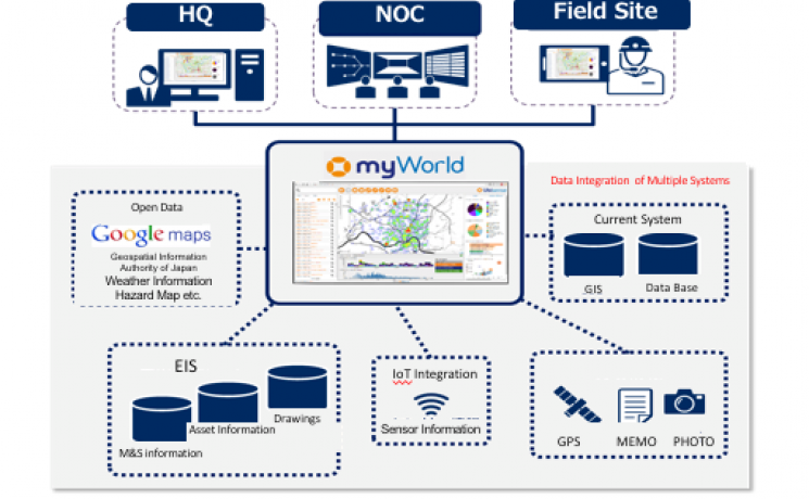
Ubisense myWorld is software that integrates and displays various data existing internally or externally in your office on to a map/screen. It can be accessed via a website or mobile environment and its intuitive interface is simple to use.
Businesses involved in telecommunications, utilities, CATV management or in providing maintenance for infrastructure facilities are facing many business challenges. These include visualisation of facility status, streamlining of field operations and prompt response to a disaster situation. However, most business operators’ systems such as existing GIS (geospatial information system), relevant internal systems and databases are all run independently. To customise and integrate all these systems is time-consuming and costly.
As a result, information sharing among departments or business operations cannot proceed because access to information from outside the office is limited. The data assets both inside and outside of the company are not effectively utilised so an improvement in the efficiency of field work cannot progress.
Ubisense myWorld is able to utilise the current GIS effectively by abundant open API. By introducing Ubisense myWorld, businesses realise three times the amount of time-saving compared to replacing the whole system and can simply integrate each system and visualise the data on a map quickly without disturbing current operations. This avoids replacing systems but enables business to utilise and upgrade what they have cost effectively and quickly.
Additionally, by integrating and visualising various information, users will be able to streamline field work and facility management as well as generate additional value such as statistics/marketing through IoT integration using big data such as weather information, traffic information, sensor information and such from equipment and facilities.
With Ubisense myWorld NESIC meets its customers’ total needs from system integration to operation and maintenance and will develop applications to meet the individual needs of clients, such as streamlining operations and disaster restoration.
In addition, by combining its mobile line service “NETS Wireless” NESIC can provide countermeasures against the risk of an information leak through the use of its high security closed circuit.
NESIC is aiming for a total revenue of 1.5 billion yen over the next three years by expanding its sales to telecommunications carriers and electricity, water and sewage and CATV operators, etc.
myWorld is now the IQGeo Platform
The 6.0 release of our software included a product name change from myWorld to the IQGeo Platform. This change reflects our focus on the IQGeo corporate brand that was launched at the beginning of 2019. Our website and latest product user interface have made the transition from the old myWorld name to the new IQGeo Platform name. Learn more about the IQGeo Platform 6.0 release.
*IQGeo launched to accelerate global growth of geospatial software
On January, 3, 2019, we launched the new IQGeo corporate brand, following the completion of the sale of the Ubisense brand and RTLS SmartSpace division.
 Previous


